Wheat is one of the oldest and most important crops cultivated by humans. Its history stretches back over 10,000 years, and its journey from wild grass to global staple has played a central role in shaping human civilization. This article explores how humankind first encountered wheat, how it was domesticated, and how it has evolved to become an essential part of our diet and economy.
Early Beginnings: Discovery and Domestication
The story of wheat begins in the Fertile Crescent, a region that stretches from modern-day Iraq through Syria, Turkey, and into Israel. This area is often referred to as the “Cradle of Civilization” because it is where many early agricultural practices began. Around 10,000 to 12,000 years ago, wild wheat species such as Triticum dicoccum (einkorn wheat) and Triticum turgidum (emmer wheat) grew naturally in the region. Early humans, who were primarily hunter-gatherers, likely began to notice the edible nature of these plants and started collecting the seeds.
The domestication of wheat was a gradual process. Over time, people began selecting the best seeds from wild wheat, and this process of artificial selection led to the development of wheat varieties with larger seeds and higher yields. By about 9,000 years ago, ancient people in the Fertile Crescent began planting wheat deliberately. This shift from gathering to farming marked the beginning of agriculture and the rise of early human settlements.
Wheat Spreads Across the World
As agricultural techniques improved, so did the spread of wheat. Wheat cultivation spread from the Fertile Crescent to neighboring regions, including Egypt, Greece, and Rome. The ancient Egyptians were among the first to develop advanced techniques for growing wheat along the banks of the Nile River. The regular flooding of the river provided nutrient-rich soil, making it ideal for wheat farming.
By the time of the Roman Empire, wheat had become a staple food in many Mediterranean countries. The Romans valued wheat for its nutritional content and versatility, using it to make bread, porridge, and other foods. Roman military campaigns also played a role in spreading wheat to other parts of Europe and North Africa, helping to establish it as a key crop throughout the empire.
The Middle Ages: Wheat in Europe
During the Middle Ages, wheat continued to be an essential crop in Europe. However, the growth of wheat farming faced several challenges, including limited knowledge of crop rotation, unpredictable weather patterns, and the threat of diseases and pests. Despite these challenges, wheat remained an important food source, particularly for the growing urban populations of Europe.
In medieval Europe, wheat was primarily used to make bread, which was a dietary staple for both the rich and the poor. However, the quality of the bread varied greatly depending on social class. The wealthier classes could afford fine white bread made from finely milled wheat flour, while the poorer classes often had to make do with coarser, darker bread made from rye or barley.
The Age of Exploration: Wheat Across the Atlantic
The Columbian Exchange, which began after Christopher Columbus’s voyages to the Americas in the late 15th century, led to the introduction of wheat to the New World. Wheat was brought to the Americas by European settlers, and it quickly became an important crop in the newly colonized territories. By the 17th century, wheat was being grown in what are now the United States and Canada, where the fertile soil of the Great Plains proved ideal for large-scale wheat cultivation.
In the United States, wheat farming grew rapidly in the 19th century, particularly with the expansion of the frontier and the development of new farming techniques. The U.S. became one of the world’s leading wheat producers, a position it holds to this day.
The Industrial Revolution: Wheat and Flour Milling
The Industrial Revolution in the 18th and 19th centuries brought about major changes in how wheat was processed and consumed. Advances in milling technology, including the development of roller mills, made it possible to produce finer, more consistent flour in large quantities. This revolutionized the flour milling industry and made white bread more widely available, even to the working classes.
At the same time, the advent of refrigeration and the development of modern transportation systems allowed wheat and flour to be transported more efficiently, both domestically and internationally. This global trade in wheat and flour helped to increase the availability of wheat-based products around the world.
Modern Wheat: Varieties and Global Impact
Today, wheat is one of the most widely cultivated crops in the world. There are three main types of wheat: hard red wheat, soft red wheat, and durum wheat. Each type is used for different purposes: hard red wheat is typically used for bread-making, soft red wheat is used for pastries and cakes, and durum wheat is used to make pasta.
Wheat is grown in a wide variety of climates, from the dry plains of the United States and Canada to the temperate regions of Europe and Asia. The expansion of irrigation and the development of genetically modified (GM) wheat varieties have further increased wheat yields and helped farmers adapt to changing climate conditions.
Today, wheat is a crucial crop not only for human food but also for animal feed, biofuel production, and industrial uses such as paper-making and bioplastics. The global wheat market is one of the largest and most dynamic commodity markets in the world, with wheat prices influenced by factors such as weather patterns, geopolitical events, and economic conditions.
Conclusion
The history of wheat is intertwined with the history of human civilization. From its origins in the Fertile Crescent to its spread across the globe, wheat has played an essential role in shaping human diets, economies, and cultures. As we look to the future, the continued cultivation and consumption of wheat will remain vital to feeding the world’s growing population and addressing the challenges of climate change and global food security.
Wheat is one of the most important staple crops worldwide, with a significant role in global food security and the agricultural economy. It serves as the primary source of food for billions of people and is also a key commodity in the financial markets. The relationship between wheat production and the commodity market is intricate and complex, shaped by various factors such as weather conditions, geopolitical events, agricultural policies, and technological advancements. This article explores the links between wheat production and the commodity market, highlighting how market participants react to changes in supply and demand and the financial implications of wheat-related volatility.
The Role of Wheat in the Global Commodity Market
Wheat is a major commodity traded globally, with the commodity market serving as a marketplace where futures and options contracts are bought and sold. These financial instruments are essential for managing price risks and speculating on future price movements. Major wheat-producing countries, such as the United States, Canada, Russia, and the European Union, are key players in the global wheat market, with the commodity being used for various purposes, including human consumption, animal feed, and industrial products.
Commodity exchanges such as the Chicago Board of Trade (CBOT) and the Euronext in Paris facilitate the trading of wheat futures, making it possible for farmers, traders, and investors to hedge against price fluctuations. As such, fluctuations in wheat prices can significantly impact both agricultural producers and financial markets, making wheat a vital commodity in the broader economic landscape.
Factors Influencing Wheat Prices in the Commodity Market
The price of wheat in the commodity market is highly volatile, influenced by a combination of domestic and global factors. Some of the key drivers include:
1. Weather Conditions
Weather plays a critical role in wheat production. Factors such as droughts, floods, and extreme temperatures can cause significant fluctuations in the yield. A poor harvest due to adverse weather conditions can lead to a reduction in supply, which, in turn, drives up prices. Conversely, a bumper crop in major wheat-producing regions can lead to oversupply, resulting in a price decline. This volatility makes wheat prices sensitive to weather patterns, particularly in regions with unpredictable climates.
2. Geopolitical Events
Wheat production and prices are often affected by geopolitical events that disrupt trade routes or cause changes in export restrictions. For example, when major wheat exporters such as Russia or Ukraine face political instability or conflicts, their ability to export wheat may be hindered, leading to supply shortages on the global market. Similarly, trade wars or tariffs imposed by countries can influence wheat prices by restricting access to certain markets.
3. Agricultural Policies and Subsidies
Government policies play a significant role in shaping wheat production and the commodity market. In many countries, farmers receive subsidies for wheat production, which can encourage or discourage wheat cultivation. Changes in agricultural policies, such as the introduction of export bans, tariffs, or changes to subsidy programs, can influence global wheat prices by affecting supply and demand dynamics. For instance, if a major wheat-producing country decides to reduce wheat subsidies, it may lead to a decrease in production, causing supply constraints and pushing prices higher.
4. Currency Exchange Rates
Currency fluctuations also play a key role in the wheat commodity market. Wheat is traded in US dollars globally, and as such, fluctuations in the value of the dollar can influence wheat prices. A stronger dollar can make wheat more expensive for buyers in other countries, leading to reduced demand. Conversely, a weaker dollar may make wheat more affordable to international buyers, increasing demand and driving up prices.
5. Demand from Emerging Markets
Emerging markets, particularly in regions such as Asia and Africa, are seeing increased demand for wheat as their populations grow and diets evolve. This rising demand, particularly for wheat-based products like bread and pasta, can place pressure on global wheat supply and drive up prices. As these markets become more significant consumers of wheat, the financial markets must account for shifting demand patterns that affect the balance between global supply and demand.
The Impact of Wheat Price Fluctuations on the Commodity Market
The wheat market is inherently volatile, and the price of wheat can experience substantial fluctuations due to the various factors discussed above. The volatility in wheat prices has significant financial implications for both producers and market participants.
1. Agricultural Producers
For wheat farmers, price volatility can lead to uncertainty and financial stress. When wheat prices are high, farmers benefit from greater revenue, but when prices fall, their income is significantly reduced. This volatility can affect farmers’ ability to plan for the future, secure financing, and invest in equipment and land improvements. Consequently, farmers often use commodity futures to hedge against price fluctuations, locking in prices for their future wheat harvests to mitigate risk.
2. Investors and Speculators
Investors and speculators in the commodity markets closely monitor wheat prices, looking for opportunities to profit from price fluctuations. Futures contracts and options allow investors to bet on the direction of wheat prices, enabling them to gain from both rising and falling prices. However, the high volatility of wheat prices also means that these financial instruments come with significant risks. As such, institutional investors, including hedge funds and commodity trading firms, actively track wheat market indicators to make informed decisions on trading strategies.
3. Food Price Inflation
Wheat price fluctuations can have a direct impact on food prices, especially in regions where wheat is a staple crop. Higher wheat prices can lead to increased costs for bread, pasta, and other wheat-based products. This can contribute to food price inflation, which affects consumers, particularly in developing countries where wheat is a primary source of calories. In such cases, the financial markets may respond to food price inflation with broader economic impacts, including changes in interest rates and fiscal policies.
4. Global Supply Chain and Trade
The commodity market is also influenced by global supply chain dynamics. Wheat prices can affect the competitiveness of exporting and importing countries, particularly in regions where wheat production is heavily dependent on imports. For example, if wheat prices rise sharply, countries that import wheat may experience higher costs for wheat-based products, leading to economic strain. Conversely, exporters may benefit from higher prices, but they may also face logistical challenges as demand outpaces supply.
Conclusion
The relationship between wheat production and the commodity market is complex and multifaceted. Factors such as weather conditions, geopolitical events, agricultural policies, and currency exchange rates all contribute to the price volatility that characterizes the wheat market. For producers, traders, investors, and policymakers, understanding these dynamics is essential for making informed decisions and mitigating risks.
Wheat is not only a vital food source but also a significant financial asset in the global economy. As demand for wheat continues to grow, especially in emerging markets, the importance of monitoring and responding to fluctuations in the commodity market will only increase. For investors and financial professionals, staying informed about wheat production trends, price movements, and market drivers is crucial to navigating this dynamic market and taking advantage of opportunities as they arise.
In the modern world of agricultural finance, satellite data has become a powerful tool for monitoring wheat productivity and predicting crop yields. By tracking key indicators such as the Normalized Difference Vegetation Index (NDVI), Total Above Ground Production (TAGP), and the Total Wheat Supplyable Output (TWSO) – also known as the harvestable plant product – investors, farmers, and agricultural analysts are able to make better-informed decisions. This article explores the impact of using these satellite-based indicators on the financial market, highlighting how they can affect the wheat trade, commodity prices, and investment strategies.
Satellite Data in Wheat Productivity Monitoring
Satellite-based indicators provide real-time insights into the health, growth, and potential yield of wheat crops. These indicators are gathered through remote sensing technologies, primarily using optical and radar satellites. By tracking wheat productivity, satellite data helps identify trends that can significantly influence wheat-related financial markets.
1. NDVI (Normalized Difference Vegetation Index)
NDVI is a widely used index to assess the density and health of vegetation by measuring the difference between infrared and visible light reflected by plants. This index is a key indicator of crop health and helps estimate biomass and growth stages, providing early warnings about potential issues such as drought, pests, or diseases that could impact yields.
For wheat production, NDVI values are closely monitored throughout the growing season. A higher NDVI indicates robust crop health and higher productivity, while a lower NDVI signals potential yield reductions. For financial markets, fluctuations in NDVI values can influence wheat futures and commodity prices, as traders anticipate changes in supply.
2. TAGP (Total Above Ground Production)
TAGP refers to the total biomass produced above the soil surface, including both leaves and stems. It is a key indicator of crop yield potential, and measuring it helps predict how much wheat a region could harvest. TAGP is closely linked to both NDVI and yield, providing a more direct indication of the amount of grain that can be harvested.
In the financial markets, changes in TAGP can lead to adjustments in supply forecasts. If satellite data indicates lower TAGP, traders may anticipate a smaller wheat harvest, driving up wheat prices due to expected shortages. Conversely, high TAGP values can signal an abundant harvest, leading to price declines as the market anticipates an oversupply.
3. TWSO (Total Wheat Supplyable Output)
TWSO represents the harvestable portion of a crop that can be used for human consumption or industrial purposes. It is a comprehensive measure that takes into account both the amount of wheat produced and the quality of the crop. This indicator is critical for determining not only the quantity but also the quality of the wheat available for trade.
TWSO is influenced by various factors, such as water availability, temperature, and nutrient levels. Monitoring this indicator through satellite data helps farmers, traders, and investors anticipate fluctuations in wheat supply, which can directly impact global wheat prices and agricultural commodity investments.
Impact on the Financial Market
A. Influence on Wheat Prices
The primary way in which satellite-based productivity monitoring affects the financial market is through its influence on wheat prices. As these productivity indicators are updated regularly, they provide real-time insights into the current state of the wheat crop in different regions. Investors and traders who rely on this data can adjust their market strategies, affecting the buying and selling of wheat futures.
Price Volatility: Price volatility in wheat markets can be significantly influenced by unexpected changes in the indicators. For example, a sudden drop in NDVI or TAGP due to a drought or disease outbreak can lead to a spike in wheat prices as traders predict lower future yields. Conversely, a surge in TWSO could lead to a drop in prices as markets anticipate an abundant supply.
Forecasting and Speculation: Financial markets rely heavily on accurate forecasting. Satellite data offers a more reliable method for forecasting crop yields than traditional methods. As satellite data becomes more accurate and widespread, investors and traders can anticipate market movements based on indicators like NDVI, TAGP, and TWSO.
B. Agricultural Commodity ETFs and Investment Opportunities
In recent years, exchange-traded funds (ETFs) focused on agricultural commodities, including wheat, have gained popularity. These financial products allow investors to buy and sell shares based on the performance of agricultural markets. Satellite data plays a crucial role in helping fund managers assess the health of the wheat market, as it provides early insights into productivity, which can influence investment strategies.
Hedging and Risk Management: Investors in wheat-related ETFs or commodity markets often use satellite data to hedge against risk. For example, if NDVI data suggests that a major wheat-producing region is underperforming, investors can hedge their positions or sell off contracts in anticipation of price increases. Conversely, strong satellite data showing high crop productivity can encourage investments in wheat ETFs with expectations of stable or lower wheat prices.
Global Wheat Supply Chains: Satellite data on wheat production is also vital for understanding global supply chains. Since wheat is produced in many regions around the world, disruptions in one area (such as a failed harvest due to bad weather) can have ripple effects on the global market. Investors and financial institutions that track satellite-based productivity indicators can better predict these disruptions and adjust their strategies accordingly.
C. Government Policies and Subsidies
Governments around the world also use satellite data to monitor wheat production, particularly in terms of subsidy allocation and agricultural planning. Accurate, up-to-date data on wheat productivity can guide decisions about subsidies, import-export policies, and trade agreements.
Policy Adjustments: Financial markets and investors pay close attention to changes in agricultural policies, especially in key wheat-producing countries. Satellite monitoring can influence the timing and scope of government intervention in the market. If productivity indicators suggest a poor wheat harvest, governments may offer subsidies to farmers or adjust import/export quotas, affecting market conditions and prices.
Insurance and Risk Coverage: Many wheat producers rely on government-backed crop insurance to mitigate the financial risks associated with poor harvests. Satellite-based indicators like NDVI and TAGP can help insurers assess the risk of crop failure, leading to more accurate risk coverage for farmers and potentially stabilizing market fluctuations.
Conclusion
The ability to monitor wheat productivity indicators such as NDVI, TAGP, and TWSO through satellite data has a profound impact on the financial market. By providing real-time insights into the health and yield potential of wheat crops, these indicators allow traders, investors, and policymakers to make better-informed decisions. Fluctuations in wheat production can lead to price volatility, affecting commodity futures and investment opportunities. As satellite technology continues to improve, its influence on the agricultural financial market will likely grow, offering more accurate forecasts and potentially reducing risk in the global wheat market.
Wheat production is an essential component of the global agricultural economy, with wheat being one of the most widely consumed staples in the world. However, the relationship between wheat production and the currency exchange market is often overlooked. In reality, currency exchange rates play a critical role in shaping the dynamics of wheat production, trade, and pricing. This article explores how the currency exchange market impacts wheat production, including both direct and indirect effects.
Understanding the Role of Currency Exchange in Wheat Trade
Wheat is a globally traded commodity, with major producers such as the United States, Canada, Russia, and the European Union exporting large quantities of wheat to international markets. The price of wheat is often quoted in U.S. dollars, and fluctuations in exchange rates can have significant effects on the global trade of wheat.
For instance, when the U.S. dollar strengthens relative to other currencies, wheat exports from the United States may become more expensive for foreign buyers. As a result, countries importing wheat may seek cheaper alternatives from other regions where currencies have depreciated relative to the dollar. Conversely, when the U.S. dollar weakens, American wheat becomes more competitively priced on the global market, potentially boosting exports.
The interplay between currency exchange rates and wheat trade highlights the interconnectedness of global agriculture markets and financial markets. A fluctuation in the exchange rate of a major wheat-producing country can directly influence its ability to export wheat and the prices at which it can sell its wheat internationally.
Currency Exchange and Wheat Production Costs
Currency fluctuations also impact the costs of inputs for wheat production, including fertilizers, seeds, machinery, and labor. Wheat producers who rely on imported inputs are directly affected by changes in currency exchange rates. A weaker local currency makes imported goods more expensive, which can lead to higher production costs for wheat farmers. In contrast, a stronger local currency may reduce the cost of imported inputs, thus benefiting farmers by lowering their overall production expenses.
For example, a wheat farmer in Argentina, where the local currency is subject to significant volatility, could see changes in input costs depending on the value of the Argentine peso relative to the U.S. dollar. A devaluation of the peso could lead to higher prices for imported fertilizers and machinery, thereby increasing the cost of wheat production. On the other hand, a stronger peso could reduce input costs and provide an opportunity for farmers to expand production or reduce prices to remain competitive.
The Impact of Currency Exchange on Wheat Prices
Currency exchange rates also affect the price of wheat on both the local and international markets. As a globally traded commodity, the price of wheat is influenced by supply and demand factors, as well as exchange rate movements. When a country’s currency depreciates, wheat prices in that country may rise in local currency terms, even if the price of wheat on the global market remains stable. This can make wheat less affordable for domestic consumers, leading to inflationary pressures on food prices.
On the other hand, a strong local currency may make wheat cheaper for domestic consumers, but it could make exports less competitive in the international market. As wheat producers strive to maintain their market share, they may face challenges in pricing their product competitively when exchange rates work against them. For instance, if the Russian ruble strengthens against the U.S. dollar, Russian wheat may become more expensive for foreign buyers, potentially reducing Russia’s wheat exports.
Hedging Strategies in the Currency Exchange Market
To mitigate the risks posed by currency exchange rate fluctuations, wheat producers, exporters, and traders often engage in hedging strategies. Hedging is a financial strategy that allows businesses to protect themselves from adverse currency movements by locking in a fixed exchange rate for future transactions.
Wheat exporters may use forward contracts, options, or other derivatives to hedge against the risk of currency fluctuations that could impact their sales. By locking in a specific exchange rate, wheat exporters can ensure that they will receive a predictable revenue stream in their local currency, even if the value of the U.S. dollar or other major currencies changes. Similarly, wheat producers who purchase imported inputs can hedge against the risk of rising input costs by entering into currency hedging contracts.
Hedging strategies provide grain producers and exporters with a safety net against currency market volatility, allowing them to better manage price risks and stabilize their financial performance. However, the effectiveness of hedging depends on various factors, including market conditions, timing, and the accuracy of forecasts regarding currency movements.
Currency Exchange and Export Competitiveness
Wheat-producing countries constantly compete in the global market to secure export contracts. Currency exchange rates are a key factor in this competition, as fluctuations in exchange rates can influence the relative price of wheat from different countries.
For example, if the Canadian dollar weakens against the U.S. dollar, Canadian grain may become more competitively priced compared to grain from the United States. This could lead to an increase in demand for Canadian grain, benefiting Canadian farmers and exporters. On the other hand, if the Russian ruble weakens, Russian grain may become more attractive to international buyers, increasing exports from Russia.
Countries that have large-scale wheat production and export sectors are particularly sensitive to currency exchange rate movements. A favorable exchange rate can enhance a country’s competitiveness in the global wheat market, while an unfavorable rate can reduce demand for its exports.
Conclusion
The relationship between wheat production and the currency exchange market is complex and multifaceted. Currency fluctuations influence the cost of production, the competitiveness of wheat exports, and the pricing of wheat on both domestic and international markets. Wheat producers, exporters, and traders must be aware of the potential risks and opportunities presented by currency movements, and many use hedging strategies to mitigate the impact of exchange rate volatility.
As global wheat markets continue to evolve, the interconnectedness between agriculture and the currency exchange market will remain a critical factor in shaping the future of wheat production and trade. Understanding the dynamics of currency exchange and its impact on wheat can help producers and investors navigate the challenges of a fluctuating global economy.
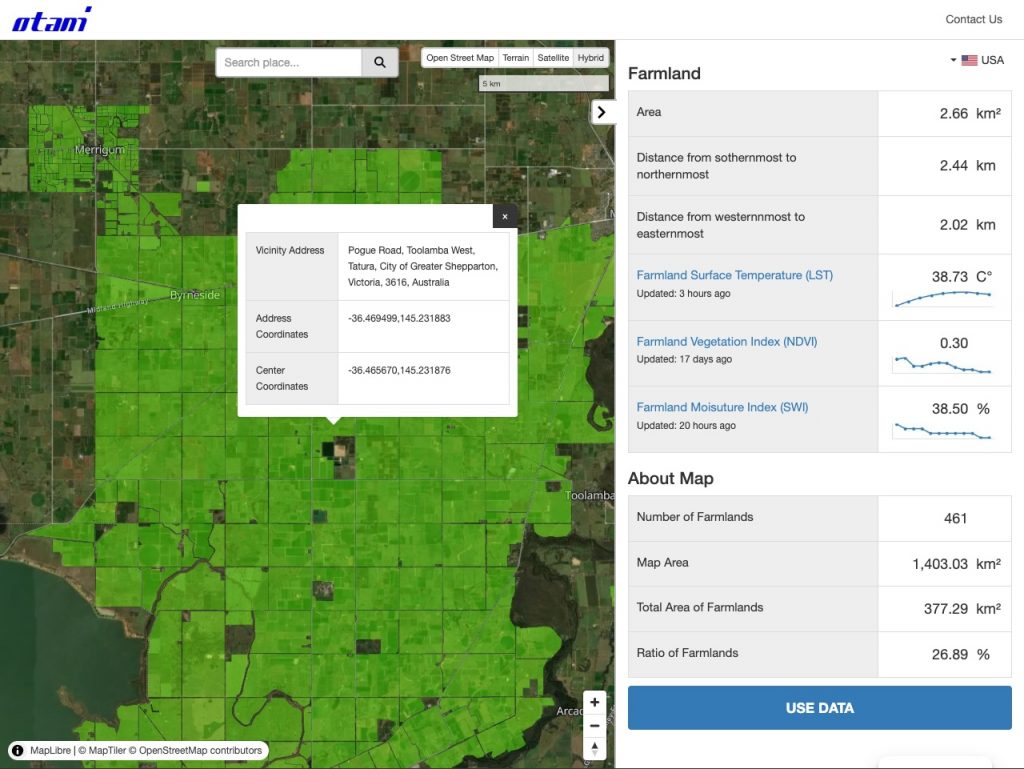
Offering easy-access to satellite data for all professionals — Just in One Click
We are proud to announce the official launch of its service, designed to monitor farmland on a global scale. This service provides users with instant access to crucial agricultural indices, including Farmland Surface Temperature, Farmland Vegetation Index (NDVI), and Farmland Moisture Index, all at the click of a button.
The service is equipped with a user-friendly interface that allows individuals to explore a global map overlaid with green polygons representing farmland areas. By simply clicking on any polygon, users can instantly view the latest data for these indices, enabling them to make informed decisions and gain deeper insights into farmland conditions worldwide.
The service data is derived from reliable satellite sources, ensuring accuracy and timeliness. Designed for use in various industries, including agriculture, finance, and environmental research, this tool is set to transform how stakeholders interact with and manage farmland resources.
Key Features of the service:
Global Coverage: The service provides comprehensive data on farmlands across the globe, to be an invaluable tool for farmers, agronomists, researchers, and businesses in agriculture.
Instant Insights: With just one click, users can access detailed information on surface temperature, vegetation health, and moisture levels of selected farmlands.
User-Friendly Design: The intuitive interface ensures accessibility for users of all technical levels.
Free of Charge:The service is currently available free of charge, with the goal of providing accessible, reliable data to a broad audience.
Global access in five languages – The service supports English, Japanese, Spanish, French, andChinese, ensuring accessibility for a worldwide audience. (Customer support is available in English and Japanese only.)
We use technologies like cookies to store and/or access device information. We do this to improve browsing experience and to show personalized ads. Consenting to these technologies will allow us to process data such as browsing behavior or unique IDs on this site. Not consenting or withdrawing consent, may adversely affect certain features and functions.
Functional
Always active
The technical storage or access is strictly necessary for the legitimate purpose of enabling the use of a specific service explicitly requested by the subscriber or user, or for the sole purpose of carrying out the transmission of a communication over an electronic communications network.
Preferences
The technical storage or access is necessary for the legitimate purpose of storing preferences that are not requested by the subscriber or user.
Statistics
The technical storage or access that is used exclusively for statistical purposes.The technical storage or access that is used exclusively for anonymous statistical purposes. Without a subpoena, voluntary compliance on the part of your Internet Service Provider, or additional records from a third party, information stored or retrieved for this purpose alone cannot usually be used to identify you.
Marketing
The technical storage or access is required to create user profiles to send advertising, or to track the user on a website or across several websites for similar marketing purposes.