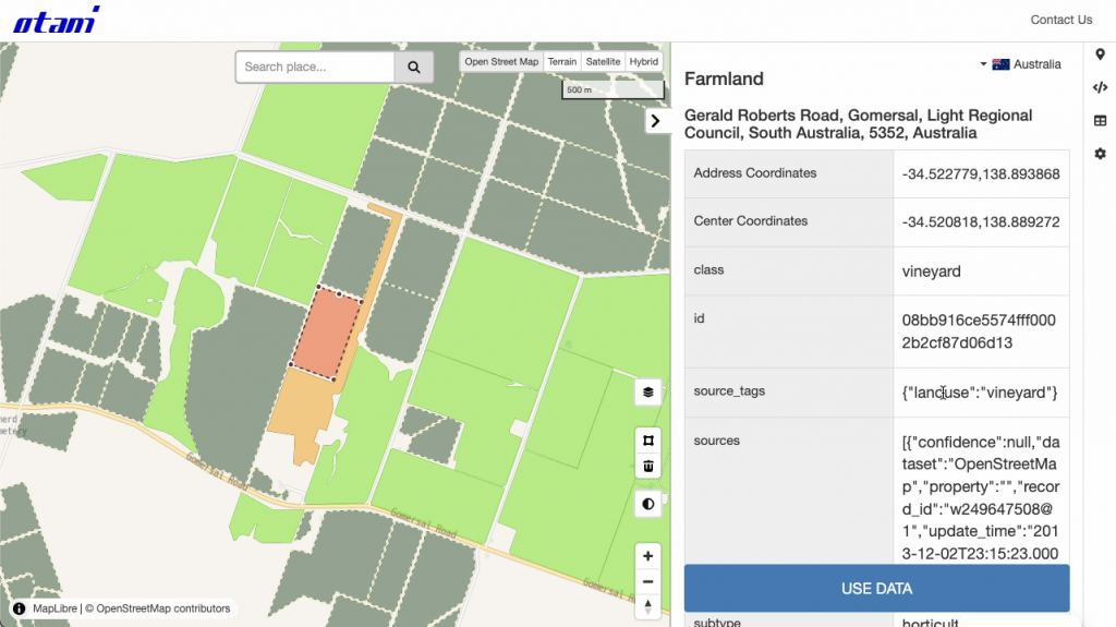
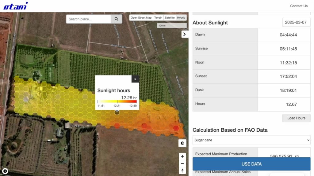
We are excited to announce a major enhancement to our agricultural data service, further expanding its capabilities to support customized data analysis and visualization. Our platform, which already provides instant access to critical farmland indices—including Farmland Surface Temperature, NDVI, Farmland Moisture Index, Shadow & Sunlight Calculations, and Soil Data—now enables users to add and visualize their own geospatial data for deeper insights and better decision-making.
Key Features of the Service:
Global Coverage: A valuable tool for agricultural professionals worldwide.
Instant Insights: One-click access to farmland temperature, vegetation health, and moisture levels.
User-Friendly Design: Accessible for users of all technical levels.
Multilingual Support: Available in English, Japanese, Spanish, French, and Chinese.
Shadow & Sunlight Calculations: Understand farmland shadows based on building structures and sunlight exposure.
Comprehensive Soil Data: Gain insights into essential soil characteristics like pH, organic carbon, and nitrogen levels.
New Feature: Custom Data Upload & Visualization
This week, we are introducing a new feature that allows users to add and visualize their own geospatial data. Key capabilities include:
User Data Integration: Paste your own GeoJSON data into our editor, and visualize it directly on the map.
Custom Data Retrieval: Extract relevant Farmland Surface Temperature, NDVI, Soil Data, and Sunlight Exposure based on your geospatial boundaries.
Interactive Drawing Tool: No GeoJSON file? No problem! Users can draw polygons directly on the map to retrieve and analyze data for their selected farmland.
This new feature enhances flexibility and personalization, allowing farmers, agronomists, and researchers to integrate their own datasets for more precise analysis and decision-making.
Example (Farmland URL & Downloadable GeoJSON file)
We are excited to announce the latest enhancement to our agricultural data service, further expanding its capabilities to provide essential insights for farmers, agronomists, researchers, and agricultural businesses worldwide. Our service already offers instant access to critical farmland indices, including Farmland Surface Temperature, Farmland Vegetation Index (NDVI), Farmland Moisture Index, and shadow & sunlight calculations. Now, we are introducing global soil data, enabling users to understand essential soil characteristics for improved decision-making in agriculture.
Global Coverage: A valuable tool for agricultural professionals worldwide.
Instant Insights: One-click access to farmland temperature, vegetation health, and moisture levels.
User-Friendly Design: Accessible for users of all technical levels.
Multilingual Support: Available in English, Japanese, Spanish, French, and Chinese.
Shadow & Sunlight Calculations: Provides insights into farmland shadows based on building structures and sunlight exposure timing.
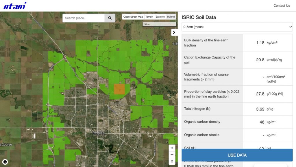
New Feature: Global Soil Data Integration
We are adding a comprehensive set of global soil data, including:
Bulk density of the fine earth fraction
Cation Exchange Capacity (CEC)
Volumetric fraction of coarse fragments (>2 mm)
Clay, sand, and silt particle proportions
Total nitrogen (N)
Soil pH
Soil organic carbon content, density, and stocks
Advancing Crop Yields Predictions
With this expansion, we are now equipped to predict crop yields . By integrating soil data with our existing indices, we provide a powerful resource for agriculture, helping stakeholders optimize land use, forecast production, and make informed agronomic decisions.
El trigo es uno de los cultivos más extendidos en el mundo, y su éxito depende en gran medida del tipo y la calidad del suelo. El suelo desempeña un papel fundamental en el crecimiento del trigo, ya que proporciona los nutrientes esenciales, el agua y la estructura para el desarrollo saludable de las raíces. El tipo de suelo, la textura, el pH, la fertilidad y las condiciones de drenaje influyen en el rendimiento del trigo y en la calidad general del cultivo. Este artículo ofrece una visión general de los factores clave que influyen en la idoneidad del suelo para la producción de trigo.
1. Textura y estructura del suelo
La textura del suelo se refiere a la proporción de partículas de arena, limo y arcilla en el suelo, que afecta a su retención de agua, capacidad de retención de nutrientes y facilidad de laboreo. Para un crecimiento óptimo del trigo, los suelos de textura franca son ideales, ya que ofrecen un equilibrio entre capacidad de retención de agua y buen drenaje. Los suelos limosos son ricos en nutrientes esenciales y ofrecen suficiente aireación para las raíces, lo que es importante para un crecimiento sano del trigo.
Suelos arenosos
Los suelos arenosos tienen una elevada proporción de partículas de arena, lo que se traduce en un buen drenaje pero una escasa retención de agua. Aunque estos suelos pueden no retener suficiente humedad durante los períodos secos, son más fáciles de trabajar y se calientan más rápidamente en primavera. Suelen utilizarse para la producción de trigo en regiones con precipitaciones de moderadas a escasas, donde se dispone de riego para complementar las necesidades de agua.
Suelos arcillosos
Los suelos arcillosos tienen una mayor proporción de partículas finas, lo que permite una mejor retención del agua pero un drenaje más lento. Aunque los suelos arcillosos pueden proporcionar un entorno estable para el trigo durante los periodos secos, son propensos al encharcamiento y a una aireación deficiente si no se gestionan adecuadamente. El laboreo y el drenaje adecuados son esenciales en suelos arcillosos para evitar la podredumbre de las raíces y otras enfermedades que pueden afectar negativamente al rendimiento del trigo.
Suelos limosos
Los suelos limosos, con una mezcla equilibrada de arena, limo y arcilla, suelen considerarse los mejores para la producción de trigo. Proporcionan un drenaje adecuado al tiempo que retienen suficiente humedad y son ricos en nutrientes, lo que favorece un crecimiento sano. Los suelos francos son ideales para la mayoría de las regiones productoras de trigo, ya que ofrecen un buen equilibrio entre retención de agua y aireación.
2. pH del suelo
El nivel de pH del suelo indica su acidez o alcalinidad y tiene un impacto significativo en la disponibilidad de nutrientes para las plantas. El trigo crece mejor en suelos con un pH comprendido entre 6,0 y 7,5, que se considera de neutro a ligeramente alcalino. Los suelos demasiado ácidos (por debajo de 6,0) pueden limitar la disponibilidad de nutrientes esenciales como el fósforo, el calcio y el magnesio, mientras que los suelos muy alcalinos (por encima de 7,5) pueden provocar carencias de micronutrientes.
Los agricultores pueden tener que ajustar los niveles de pH del suelo utilizando cal para elevar el pH en suelos ácidos o azufre para bajar el pH en suelos alcalinos, dependiendo de las condiciones locales.
3. Fertilidad del suelo
La fertilidad del suelo es la capacidad de éste para proporcionar nutrientes esenciales para el crecimiento de las plantas. El trigo requiere diversos nutrientes, como nitrógeno, fósforo, potasio y oligoelementos como zinc, hierro y manganeso. El nitrógeno, en particular, es fundamental para el desarrollo del trigo, ya que promueve un crecimiento vegetativo vigoroso y garantiza un alto rendimiento.
Fertilización
En muchas regiones productoras de trigo, los suelos pueden no proporcionar niveles suficientes de nutrientes para una producción óptima del cultivo, lo que hace necesario el uso de fertilizantes. Los fertilizantes nitrogenados suelen aplicarse a los cultivos de trigo para favorecer el crecimiento durante las primeras etapas, mientras que el fósforo y el potasio se añaden a menudo para promover el desarrollo de las raíces y mejorar la salud general de la planta.
Materia orgánica
La incorporación al suelo de materia orgánica, como compost o cultivos de cobertura, puede mejorar significativamente su fertilidad al aumentar la disponibilidad de nutrientes, mejorar la estructura del suelo y promover la actividad microbiana. La materia orgánica ayuda a mantener la humedad del suelo y favorece un ecosistema sano para el crecimiento del trigo.
4. Drenaje del suelo
Un buen drenaje del suelo es esencial para evitar el encharcamiento, que puede provocar enfermedades de las raíces, una mala aireación y una reducción del rendimiento. Los suelos con un buen drenaje permiten evacuar el exceso de agua, al tiempo que retienen la humedad suficiente para que las plantas de trigo prosperen. En regiones con precipitaciones abundantes, los agricultores suelen implantar sistemas de drenaje, como el drenaje por baldosas o los drenajes superficiales, para evitar la acumulación de agua y garantizar un desarrollo adecuado de las raíces.
En las regiones secas, la retención adecuada de la humedad del suelo es igualmente importante. Los suelos demasiado arenosos pueden requerir riego para mantener los niveles de humedad adecuados para el crecimiento del trigo, mientras que los suelos con un contenido excesivo de arcilla pueden necesitar enmiendas con materia orgánica o arena para mejorar el drenaje del agua.
5. Prácticas de conservación del suelo
La erosión del suelo es una de las principales preocupaciones en el cultivo del trigo, sobre todo en zonas donde las lluvias torrenciales, los fuertes vientos o las prácticas agrícolas inadecuadas pueden provocar la pérdida de la capa superficial del suelo. Las prácticas de conservación del suelo, como la siembra directa, la rotación de cultivos y el uso de cultivos de cobertura, ayudan a preservar la calidad del suelo, prevenir la erosión y promover la producción sostenible de trigo.
Suelo para la producción de trigo
El suelo es un factor fundamental que influye en el éxito de la producción de trigo. El suelo ideal para el cultivo de trigo depende de un equilibrio de textura, pH, fertilidad y condiciones de drenaje. Los suelos limosos con un pH neutro y buena fertilidad suelen ser los mejores para el trigo, aunque los agricultores pueden adaptarse a diversos tipos de suelo mediante prácticas de gestión adecuadas. Conociendo los requisitos específicos del suelo para el trigo y adoptando las técnicas adecuadas, los agricultores pueden optimizar el rendimiento, reducir el impacto ambiental y garantizar la sostenibilidad a largo plazo de la producción de trigo.
El cereal es uno de los cultivos básicos más importantes del mundo, con diferentes variedades cultivadas en función del uso final, las condiciones de cultivo y el clima. Entre ellas, el grano duro y la sémola destacan por sus propiedades distintivas y sus amplias aplicaciones. Este artículo profundiza en los distintos tipos de grano, haciendo hincapié en el grano duro, la sémola, sus características, usos y las regiones y países donde se cultivan.
1. El trigo duro: El más duro de todos los tipos de trigo
Características
El trigo duro (Triticum durum) es una variedad dura de trigo conocida por su alto contenido en proteínas y su fuerte gluten, lo que lo hace ideal para producir pasta, cuscús y ciertos tipos de pan. Se distingue de otros tipos de trigo por sus granos grandes de color ámbar. El trigo duro es más duro que las variedades de trigo comunes y se suele moler para obtener sémola, una harina gruesa con un tinte amarillento que es un ingrediente clave en muchos platos mediterráneos.
El trigo duro tolera relativamente bien los climas cálidos y secos, y es conocido por su resistencia a la sequía. Requiere suelos bien drenados y puede cultivarse en regiones donde las precipitaciones son limitadas, aunque en algunas zonas sigue necesitando riego para prosperar.
Usos clave
El trigo duro se utiliza principalmente para producir pasta y es el preferido para elaborar productos de pasta como espaguetis, macarrones y lasaña. También se emplea en la elaboración de ciertos tipos de pan, especialmente en la cocina mediterránea y de Oriente Medio, como la focaccia y el cuscús. La sémola de trigo duro es apreciada por su textura y elasticidad, que confieren a la pasta un bocado firme al cocerla.
Regiones y países productores clave
El trigo duro se cultiva principalmente en regiones de clima cálido y seco. Algunos de los principales productores de trigo duro son:
Canadá: Canadá es el mayor exportador de trigo duro, sobre todo en las provincias praderas de Saskatchewan, Alberta y Manitoba. El fresco periodo vegetativo de Canadá es ideal para la producción de trigo duro.
Italia: Conocida por su tradición en la fabricación de pasta, Italia es uno de los mayores consumidores y productores de trigo duro de Europa. Las regiones meridionales, como Sicilia y Apulia, son zonas de cultivo clave.
Estados Unidos: En Estados Unidos, el trigo duro se cultiva principalmente en Dakota del Norte, Montana y partes de Idaho. Estas zonas tienen climas favorables para la producción de trigo duro.
Turquía: El trigo duro se cultiva ampliamente en Turquía, sobre todo en las regiones del sudeste, donde se utiliza para producir cuscús y otros productos tradicionales.
Siria y Marruecos: Estos países del norte de África y Oriente Medio también cultivan cantidades significativas de trigo duro, siendo Marruecos uno de los principales productores de la región.
2. Sémola: Harina gruesa de trigo duro
Características
La sémola es una harina más gruesa obtenida del trigo duro, y se utiliza a menudo en la producción de pasta. El término «sémola» hace referencia a la textura granulosa de la harina, que se obtiene moliendo los granos de trigo duro hasta conseguir una consistencia gruesa. La sémola tiene un alto contenido en proteínas y gluten, lo que proporciona una excelente textura y elasticidad a la masa. Suele ser de color amarillo dorado y tiene un marcado sabor a nuez.
La harina de sémola se divide a su vez en diferentes grados según su finura. Los grados más finos se utilizan para la producción de pasta, mientras que los más gruesos se emplean en el cuscús y otros productos alimenticios.
Usos principales
La sémola se utiliza principalmente en la producción de pasta, a la que su textura gruesa confiere una textura firme y masticable durante la cocción. También se emplea en la elaboración del cuscús, un plato popular en el norte de África, y en varios postres, como el pudin de sémola y la halva.
Regiones y países productores clave
La sémola se produce allí donde se cultiva trigo duro, ya que es el principal producto de la molienda de este cereal. Los países productores de sémola son en gran medida los mismos que cultivan trigo duro. Entre ellos se encuentran:
Italia: Como uno de los mayores consumidores de trigo duro, Italia también produce una cantidad significativa de sémola, utilizada principalmente para la producción de pasta.
India: La India también produce sémola, sobre todo en las regiones meridionales y occidentales, donde se utiliza para hacer upma, un popular plato de desayuno, y otras recetas tradicionales.
Egipto: La sémola es un ingrediente importante en la cocina egipcia, donde se utiliza para preparar platos como el koshari (un plato tradicional de arroz y lentejas) y postres como el basbousa.
Estados Unidos: En Estados Unidos, la sémola se produce en zonas donde se cultiva trigo duro, sobre todo en los estados septentrionales de las Grandes Llanuras, como Dakota del Norte y Montana.
3. Otros tipos de trigo y sus características
Trigo pan (trigo blando)
Uno de los tipos de trigo más cultivados es el trigo panificable (Triticum aestivum). Se utiliza principalmente para hacer pan y otros productos horneados. En comparación con el grano duro, el grano panificable tiene una textura más suave y una mayor versatilidad en sus aplicaciones.
Principales regiones productoras: Rusia, Estados Unidos, China, India y la Unión Europea son los mayores productores de trigo panificable.
Trigo rojo blando de invierno
El trigo rojo blando de invierno es otro tipo de trigo conocido por su contenido relativamente bajo en proteínas. Se utiliza principalmente para hacer pasteles, galletas, crackers y otros productos de panadería que requieren una textura más blanda.
Regiones productoras clave: Estados Unidos, sobre todo en las regiones del Medio Oeste y del Este, es un importante productor de trigo rojo blando de invierno.
Trigo rojo duro de invierno
El trigo rojo duro de invierno es una variedad con mayor contenido proteico y gluten más fuerte, que se utiliza en la producción de pan, sobre todo para elaborar panes de alta calidad.
Principales regiones productoras: Los principales productores de trigo rojo duro de invierno son Estados Unidos (Kansas, Nebraska y Oklahoma), Canadá y Rusia.
Conclusión
Los distintos tipos de trigo se adaptan a diversas aplicaciones, siendo el trigo duro y la sémola especialmente apreciados por su papel en la producción de pasta y en la cocina mediterránea. El trigo duro, por su alto contenido en proteínas y su resistencia a la sequía, se cultiva sobre todo en regiones como Canadá, Italia y Estados Unidos. La sémola, elaborada con trigo duro, se produce y utiliza en todo el mundo, sobre todo en regiones donde la pasta y el cuscús son alimentos básicos. Otras variedades de trigo, como el trigo panificable y el trigo blando y duro rojo de invierno, tienen sus propios usos y se producen en muchos países de todo el mundo. La diversidad de tipos de trigo y sus aplicaciones ponen de relieve la importancia mundial de la producción de trigo para alimentar a las poblaciones y sostener las economías.
El trigo es un cultivo básico y uno de los productos agrícolas más importantes del comercio mundial. Es esencial no sólo para la producción nacional de alimentos, sino también para los mercados internacionales, donde los países dependen de las importaciones y exportaciones de trigo para satisfacer su demanda. Tanto el trigo en grano como la harina de trigo son objeto de comercio internacional, y el flujo de trigo a través de las fronteras desempeña un papel fundament.al en la cadena mundial de suministro de alimentos. Este artículo presenta el proceso general de importación y exportación de trigo, las razones que subyacen a estas transacciones y los factores clave que influyen en el comercio.
1. La exportación de trigo: Una contribución fundamental a los mercados mundiales
Países exportadores clave
Varios países son exportadores clave de trigo, desempeñando un papel vital en el suministro mundial de este importante cultivo. Entre ellos figuran Rusia, Estados Unidos, Canadá, Australia y Francia. Estas regiones suelen ser conocidas por su clima favorable y sus explotaciones de trigo a gran escala, lo que les permite producir cantidades significativas de trigo para la exportación.
Razones para exportar trigo
Excedente de producción: Muchos de los principales países exportadores de trigo producen más trigo del que necesitan para el consumo interno. Este excedente se exporta para satisfacer las necesidades de otros países que no disponen de recursos suficientes para cultivar suficiente trigo en su territorio.
Beneficios económicos: La exportación de trigo supone una importante fuente de ingresos para los países implicados. Al vender trigo a los mercados internacionales, los países pueden aumentar la rentabilidad de su sector agrícola y fortalecer su economía en general.
Demanda mundial: El trigo es un cultivo alimentario básico con una amplia gama de usos, desde la fabricación de pan hasta la producción de pasta. La demanda de trigo sigue siendo alta en todo el mundo, especialmente en regiones con un elevado crecimiento demográfico, como algunas zonas de Asia, África y Oriente Medio. Los países que producen trigo en exceso pueden aprovechar estos mercados en expansión, garantizando así la solidez de su sector agrícola.
Seguridad alimentaria: Al exportar trigo, los países contribuyen a garantizar la seguridad alimentaria mundial. El trigo es esencial para alimentar a millones de personas en todo el mundo, y a través del comercio, las naciones pueden proporcionar un suministro fiable a los países que sufren escasez de alimentos.
Exportación de harina de trigo frente a trigo en grano
Los países pueden optar por exportar trigo en grano o harina de trigo en función de factores como el coste, la demanda del mercado y las infraestructuras.
Trigo en grano: La exportación de trigo en grano crudo suele ser más económica que la de harina porque requiere menos procesamiento. Además, el trigo en bruto es un producto versátil que los molinos harineros de los países importadores pueden utilizar para satisfacer la demanda local.
Harina de trigo: Por otra parte, la exportación de harina ofrece ventajas de valor añadido. Al exportar harina procesada en lugar de trigo crudo, los países pueden aumentar sus márgenes de beneficio, ya que la harina es un producto de mayor valor. Además, la exportación de harina puede ayudar a satisfacer las necesidades de países con una capacidad de molturación limitada o donde la demanda de alimentos procesados es mayor.
2. Importar trigo: Satisfacer la demanda interna
Principales países importadores
Los países que carecen de las condiciones climáticas, la superficie o las infraestructuras necesarias para producir suficiente trigo recurren a las importaciones para satisfacer su demanda interna. Entre estos países se encuentran muchos de Oriente Medio, el norte de África y partes de Asia, donde el consumo de trigo es elevado pero la producción local es limitada. Entre los principales importadores de trigo figuran Egipto, Indonesia, Argelia y Japón.
Razones para importar trigo
Producción nacional insuficiente: No todos los países pueden cultivar trigo en cantidades suficientes para satisfacer las necesidades de su población. Las duras condiciones climáticas, la escasez de tierras cultivables o las deficientes infraestructuras agrícolas pueden dificultar la producción de trigo. En tales casos, se hace necesaria la importación de trigo para cubrir la diferencia entre la producción nacional y el consumo.
Precio y factores económicos: A veces, importar trigo puede resultar más rentable que producirlo en el país. Por ejemplo, los países con costes laborales elevados o condiciones de cultivo desfavorables pueden considerar que importar trigo es más barato que invertir en la producción local. Los precios mundiales del trigo fluctúan debido a factores como las condiciones meteorológicas y las tendencias del mercado, y algunos países aprovechan los precios más bajos de los países exportadores.
Seguridad alimentaria: Del mismo modo que la exportación de trigo contribuye a estabilizar la seguridad alimentaria mundial, su importación es crucial para los países que dependen del trigo como principal alimento básico. Garantizar un suministro constante de trigo a través de las importaciones ayuda a protegerse contra la posible escasez causada por malas cosechas u otras interrupciones de la producción nacional.
Diversificación de las fuentes de suministro: Depender exclusivamente del trigo nacional puede ser arriesgado si la producción local sufre contratiempos como el mal tiempo o brotes de enfermedades. Importando trigo de distintas regiones, los países pueden reducir su dependencia de una sola fuente y garantizar un suministro más estable.
Importar Harina de Trigo vs. Trigo en Grano
Al igual que en el caso de la exportación, la decisión entre importar trigo en grano o harina de trigo depende de varios factores.
Trigo en grano: Muchos países prefieren importar trigo en grano porque permite la molienda local y crea puestos de trabajo en la industria molinera nacional. La importación de trigo en bruto también ofrece mayor flexibilidad en términos de almacenamiento y procesamiento local para satisfacer necesidades específicas, como diferentes tipos de harina.
Harina de trigo: Por otra parte, algunos países prefieren importar directamente harina de trigo, sobre todo los que tienen una capacidad de molturación limitada o los que dan prioridad a la harina lista para usar en la producción de alimentos. La harina es un producto más procesado y puede importarse cuando se necesita en grandes cantidades para las industrias panificadoras y de fabricación de alimentos.
3. El futuro del comercio de trigo
El comercio mundial de trigo se ve influido por diversos factores, como la situación económica, las políticas comerciales, el cambio climático y los avances tecnológicos. Como la demanda de trigo sigue creciendo, especialmente en las regiones en desarrollo, es probable que el mercado mundial del trigo se expanda. Los países pueden invertir en métodos de producción más eficientes, en la investigación de variedades de trigo resistentes a la sequía y en mejoras de las infraestructuras para satisfacer la creciente demanda.
Los acuerdos comerciales, los aranceles y las subvenciones también pueden influir en el flujo de trigo entre países. La estabilidad política y las relaciones comerciales seguirán desempeñando un papel importante a la hora de determinar qué países exportan e importan trigo y productos derivados.
Conclusión
El comercio de trigo, ya sea en grano crudo o en forma de harina procesada, desempeña un papel esencial para satisfacer la demanda mundial de alimentos. Los países productores exportan trigo para satisfacer la demanda internacional, mientras que los países con una capacidad de producción limitada importan trigo para garantizar un suministro estable de alimentos. La decisión de exportar o importar trigo, o harina de trigo, depende de factores como las consideraciones económicas, la seguridad alimentaria, la capacidad de producción local y las condiciones del mercado. La continua importancia del trigo en el sistema alimentario mundial significa que este comercio seguirá siendo una parte fundamental del panorama agrícola y económico en los años venideros.
El trigo es uno de los cultivos más importantes del mundo, esencial para la producción de diversos productos alimenticios como pan, pasta y bollería. El proceso que va desde la producción de trigo en las granjas hasta la venta de harina en los supermercados consta de varias etapas, como la cosecha, la transformación, el envasado y la distribución. Comprender este proceso ayuda a poner de relieve la importante cadena de valor que contribuye a la disponibilidad de harina en los supermercados de todo el mundo.
1. Producción de trigo en las granjas
Plantación
La producción de trigo comienza con la siembra de las semillas, normalmente en otoño o primavera, según el clima y la región. En la mayoría de los países, el trigo se cultiva en explotaciones a gran escala, donde las principales variedades son el trigo duro rojo de invierno, el trigo duro rojo de primavera, el trigo blando rojo de invierno y el trigo duro. Los agricultores eligen la variedad en función de las condiciones regionales y el uso previsto (por ejemplo, fabricación de pan, producción de pasta).
Crecimiento y desarrollo
El trigo pasa por una serie de etapas: germinación, ahijamiento (producción de brotes laterales), alargamiento del tallo, espigado (floración) y llenado del grano. A lo largo de estas etapas, los agricultores controlan el cultivo en lo que respecta al agua, los niveles de nutrientes, las plagas y las enfermedades, asegurándose de que se mantienen las condiciones óptimas para obtener altos rendimientos.
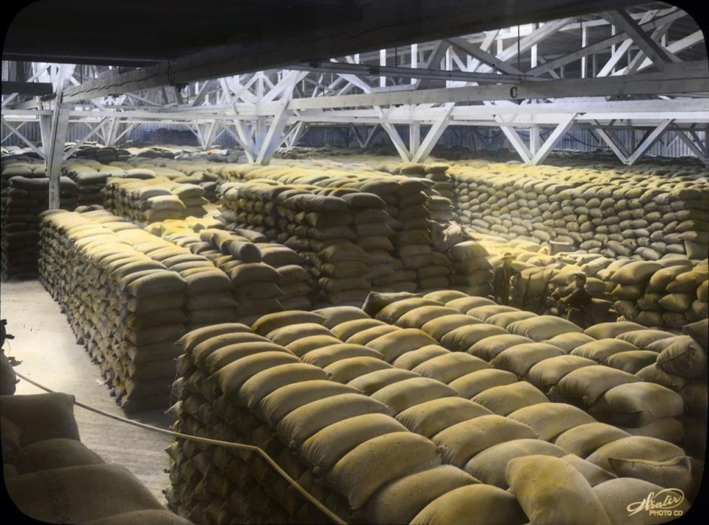
Cosecha
La cosecha suele realizarse a finales de la primavera o en verano, cuando el trigo ha madurado y los granos están secos. Se utilizan grandes cosechadoras para cortar el trigo, separar los granos de la paja y recogerlos. A continuación, el trigo cosechado se transporta a instalaciones de almacenamiento o directamente a plantas de transformación.
2. Almacenamiento del trigo
Una vez cosechado, el trigo se transporta a los silos de almacenamiento. Un almacenamiento adecuado es esencial para evitar el deterioro, la infestación por plagas y la pérdida de calidad. El trigo suele almacenarse en grandes silos que controlan la temperatura y la humedad para mantener la calidad del grano hasta que esté listo para la molienda. Dependiendo de la escala de producción, el trigo puede almacenarse durante varios meses antes de ser procesado.
3. La molienda: La transformación del trigo en harina
El siguiente paso crítico en el proceso de transformación del trigo en harina es la molienda. La molienda consiste en triturar los granos de trigo hasta convertirlos en harina utilizando equipos especializados en molinos harineros. El proceso de molienda suele seguir los siguientes pasos
Limpieza y acondicionamiento
Antes de la molienda, el trigo se limpia para eliminar impurezas como polvo, suciedad, piedras y otros materiales extraños. También se acondiciona añadiendo agua, lo que ablanda el trigo y facilita su molienda.
Molienda y cribado
Los granos de trigo se introducen en molinos, donde se trituran y muelen en partículas más pequeñas. La harina resultante se separa en distintas calidades a través de una serie de tamices. El producto final puede variar desde la harina de trigo integral, que incluye el grano entero, hasta la harina blanca refinada, a la que se le ha quitado el salvado y el germen.
Subproductos de la molienda
Durante el proceso de molienda también se producen subproductos como el salvado, el germen y las harinillas de trigo. Estos subproductos se utilizan a menudo en la alimentación animal o se transforman en otros productos, como el salvado de trigo para consumo humano.
Envasado
Una vez procesada, la harina se envasa en sacos de distintos tamaños, según el mercado y las necesidades del consumidor. El envasado incluye etiquetas con detalles como el tipo de harina, el peso, la fecha de caducidad y la información nutricional.
4. Distribución y venta de harina
Una vez envasada, la harina se distribuye a mayoristas, minoristas y supermercados. El proceso de distribución de la harina suele implicar varios canales, incluido el transporte por camión o ferrocarril desde los molinos harineros hasta los almacenes regionales, donde se almacena antes de ser enviada a los puntos de venta al por menor.
Los supermercados y las tiendas de ultramarinos suelen comprar harina a granel a los mayoristas, que luego la venden a los consumidores en cantidades más pequeñas. Los minoristas almacenan varios tipos de harina, como harina para todo uso, harina panificable, harina para pasteles y harinas especiales, como las variedades sin gluten o ecológicas, para satisfacer las diversas necesidades de los consumidores.
En algunos casos, la harina también se vende directamente a panaderías, restaurantes y otras empresas de servicios alimentarios, donde se utiliza para producir pan, pasteles, bollería y otros productos.
5. Compra del consumidor
La etapa final del proceso se produce cuando los consumidores compran harina en supermercados o tiendas locales. Los consumidores utilizan la harina para hornear y cocinar una gran variedad de productos alimenticios en casa. La harina es un ingrediente básico en muchos hogares y es adquirida regularmente por particulares, familias y empresas.
Conclusión
El viaje desde la producción de trigo en las granjas hasta la venta de harina en los supermercados es un proceso complejo que implica múltiples etapas, cada una de las cuales añade valor al producto final. Desde la siembra y la cosecha hasta la molienda, el envasado y la distribución, cada etapa de la cadena de suministro desempeña un papel fundamental para garantizar que los consumidores de todo el mundo dispongan de harina de alta calidad. Esta cadena de valor es crucial no sólo para la producción de alimentos, sino también para las economías de los países que dependen en gran medida del trigo como cultivo básico. Si comprendemos el proceso en su totalidad, podremos apreciar los esfuerzos y las tecnologías que hay detrás de llevar la harina de las granjas a las estanterías de los supermercados.
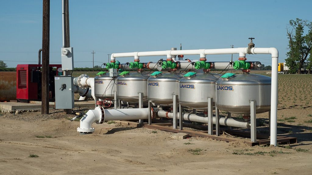
El riego desempeña un papel crucial para garantizar el éxito de la producción de trigo, especialmente en regiones donde las precipitaciones son insuficientes o irregulares. Un sistema de riego adecuado puede aumentar el rendimiento, mejorar la eficiencia hídrica y reducir el impacto de las sequías en los cultivos de trigo. Las distintas regiones del mundo se enfrentan a diferentes retos en cuanto a disponibilidad de agua, condiciones del suelo y clima, por lo que el tipo de sistema de riego utilizado debe adaptarse a las necesidades específicas de cada región. En este artículo, exploraremos los diversos sistemas de riego adecuados para la producción de trigo en distintas partes del mundo.
La importancia del riego en la producción de trigo
El trigo es un cultivo básico que necesita mucha agua para crecer de forma óptima. Un riego insuficiente puede provocar un retraso en el crecimiento, un mal llenado del grano y una reducción del rendimiento. Por el contrario, un riego excesivo puede provocar encharcamiento, salinización del suelo y una mayor susceptibilidad a las enfermedades. Por lo tanto, un sistema de riego bien diseñado y cuidadosamente gestionado es esencial para garantizar que los cultivos de trigo reciban la cantidad adecuada de agua en el momento oportuno, especialmente en regiones con precipitaciones irregulares.
Tipos de sistemas de riego
En la producción de trigo se utilizan varios sistemas de riego, cada uno con sus ventajas y limitaciones. La elección del sistema depende de factores como la disponibilidad de agua, el tamaño del campo, la topografía y el coste.
1. Sistemas de riego de superficie
El riego superficial es uno de los métodos más antiguos y utilizados, sobre todo en regiones con terreno llano y abundantes recursos hídricos. En este sistema, el agua se aplica directamente a la superficie del suelo a través de surcos, cuencas o riego por inundación.
Regiones adecuadas:
India: India es uno de los mayores productores de trigo del mundo, y el riego de superficie se utiliza ampliamente en las regiones productoras de trigo, especialmente en los estados de Punjab, Haryana y Uttar Pradesh. Estas zonas tienen un terreno relativamente llano y abundantes recursos hídricos procedentes de ríos y canales.
China: En China, especialmente en la llanura del norte del país, el riego de superficie se ha utilizado tradicionalmente para la producción de trigo. Los extensos sistemas de canales y los terrenos llanos hacen viable este sistema.
Ventajas:
Instalación sencilla y de bajo coste.
Adecuado para grandes superficies y terrenos relativamente llanos.
Funciona bien en regiones con abundantes recursos hídricos.
Limitaciones:
Despilfarro de agua e ineficacia si no se gestiona con cuidado.
Riesgo de salinización del suelo en zonas con altas tasas de evaporación.
2. Sistemas de riego por goteo
El riego por goteo consiste en suministrar agua directamente a la zona radicular de las plantas a través de una red de tubos y emisores. Este sistema es muy eficaz y utiliza menos agua que el riego por superficie, ya que minimiza la evaporación y la escorrentía.
Regiones adecuadas:
Israel: Israel lleva mucho tiempo siendo pionero en la tecnología de riego por goteo, sobre todo en regiones áridas y semiáridas. El riego por goteo se ha utilizado con éxito para la producción de trigo en el desierto del Negev y en otras zonas del país donde el agua escasea.
Australia: En Australia, donde las condiciones de sequía son habituales, el riego por goteo es cada vez más popular, sobre todo en regiones como Nueva Gales del Sur y Australia Meridional, donde se cultiva trigo.
Ventajas:
Gran eficiencia en el uso del agua, lo que lo hace ideal para zonas con recursos hídricos limitados.
Reduce la evaporación y la escorrentía, por lo que es sostenible desde el punto de vista medioambiental.
El suministro preciso de agua a la zona radicular mejora la salud de las plantas y el rendimiento.
Limitaciones:
Costes iniciales de instalación y mantenimiento elevados. -Requiere experiencia para su instalación y gestión.
3. Sistemas de riego por pivote central
El riego por pivote central es un tipo de riego por aspersión que utiliza torres giratorias para distribuir el agua uniformemente sobre grandes superficies circulares de terreno. Este sistema es más eficaz en zonas con terreno relativamente llano y se utiliza ampliamente en regiones con producción comercial de trigo a gran escala.
Regiones adecuadas:
Estados Unidos: En las Grandes Llanuras de Estados Unidos, que es una de las mayores regiones productoras de trigo del mundo, se utiliza habitualmente el riego por pivote central. Estados como Kansas, Nebraska y Oklahoma se benefician de este sistema debido a su extenso terreno llano y a la moderada disponibilidad de agua procedente de acuíferos subterráneos.
Argentina: Las zonas productoras de trigo de Argentina, sobre todo en la región pampeana, también recurren al riego por pivotes centrales para gestionar eficazmente los recursos hídricos destinados a los cultivos de trigo.
Ventajas:
Adecuado para la producción de trigo a gran escala debido a su capacidad para cubrir áreas extensas.
Distribución eficiente del agua, lo que reduce su desperdicio.
La automatización reduce los costes de mano de obra.
Limitaciones:
Elevada inversión de capital para su instalación.
Requiere una fuente fiable de agua, como aguas subterráneas o embalses.
4. Riego por goteo subsuperficial (SDI)
El riego por goteo subsuperficial es similar al riego por goteo tradicional, pero consiste en enterrar la tubería bajo la superficie del suelo. Este sistema suministra agua directamente a la zona radicular, reduciendo la evaporación y la escorrentía superficial.
Regiones adecuadas:
Egipto: En Egipto, donde los recursos hídricos son limitados y el riego es fundamental para la producción de trigo, el riego por goteo subsuperficial está ganando popularidad. El sistema es especialmente eficaz en regiones como el delta del Nilo, donde la gestión del agua es crucial.
Asia Central: Países como Uzbekistán y Kazajstán, donde la escasez de agua es un problema, han implantado el riego por goteo subsuperficial en los campos de trigo para mejorar la eficiencia en el uso del agua.
Ventajas:
Gran eficiencia en el uso del agua, lo que lo hace ideal para zonas con escasez de agua.
Reduce la evaporación y la escorrentía superficial, lo que resulta beneficioso en climas cálidos.
Mejora la estructura del suelo y reduce el crecimiento de malas hierbas.
Limitaciones:
Costes de instalación y mantenimiento elevados.
Requiere un seguimiento y una gestión cuidadosos.
5. Riego por inundación
El riego por inundación, también conocido como riego por cuenca o por crecida, consiste en inundar todo el campo con agua. Este método tradicional se utiliza menos hoy en día debido a su ineficacia, pero todavía puede encontrarse en algunas regiones.
Regiones adecuadas:
Pakistán: En Pakistán, sobre todo en las regiones de Sindh y Punjab, el riego por inundación se ha utilizado tradicionalmente para la producción de trigo. La disponibilidad de agua del sistema del río Indo favorece este método.
Egipto: El riego por inundación también es común en Egipto, especialmente en el delta del Nilo, donde el agua del río Nilo se utiliza para inundar los campos de trigo.
Ventajas:
Bajos costes de instalación y funcionamiento.
Puede utilizarse en grandes superficies llanas.
Limitaciones:
Muy ineficiente, lo que provoca un importante despilfarro de agua.
Riesgo de erosión y salinización del suelo.
Requiere un gran suministro de agua.
Conclusión
La elección del sistema de riego para la producción de trigo depende en gran medida de las condiciones regionales, como el clima, la disponibilidad de agua, el tipo de suelo y la escala de las operaciones agrícolas. El riego por superficie sigue siendo una opción popular en regiones con abundancia de agua, como la India y China, mientras que los sistemas de riego por goteo y subterráneo se adoptan cada vez más en zonas con escasez de agua, como Israel, Australia y Egipto. Los sistemas de pivote central son ideales para el cultivo de trigo a gran escala en regiones como Estados Unidos y Argentina, ya que ofrecen una distribución eficaz del agua en grandes extensiones. Cada sistema tiene sus ventajas y sus limitaciones, por lo que hay que tenerlo muy en cuenta para garantizar un uso eficiente de los recursos hídricos, maximizando el rendimiento del trigo y minimizando el impacto ambiental.
La podredumbre de la raíz del trigo es un grave problema que afecta a la producción de trigo en todo el mundo. Esta enfermedad, causada por diversos patógenos del suelo como Fusarium, Rhizoctonia, Pythium y Bipolaris, afecta a las raíces de las plantas de trigo, reduciendo la absorción de nutrientes y agua. La enfermedad puede provocar retraso del crecimiento, amarilleamiento de las hojas y, en casos graves, la muerte de la planta. Las consecuencias se manifiestan a menudo en forma de reducción del rendimiento de la cosecha y mala calidad del trigo, lo que a su vez provoca importantes pérdidas económicas. En este artículo se analizan las repercusiones económicas de la podredumbre radicular del trigo desde perspectivas microeconómicas y macroeconómicas, centrándose en su influencia sobre los agricultores, los sectores agrícolas y las economías nacionales.
Impacto económico desde una perspectiva microeconómica
Costes directos para los agricultores
Desde un punto de vista microeconómico, las repercusiones financieras directas de la podredumbre de la raíz del trigo suelen ser graves para los agricultores. La enfermedad reduce directamente el rendimiento del trigo, haciéndolo menos rentable. Los cultivos infectados pueden producir menos de la mitad de lo que producirían los cultivos sanos en condiciones óptimas, especialmente en zonas donde la enfermedad es prevalente. La reducción del rendimiento de los cultivos significa que los agricultores perciben menos ingresos, lo que puede afectar a sus medios de subsistencia y provocar inestabilidad financiera, sobre todo en el caso de los pequeños agricultores que dependen en gran medida de la producción de trigo.
Además de la pérdida de rendimiento, los agricultores también pueden incurrir en costes adicionales para gestionar la enfermedad. Estos costes pueden incluir la aplicación de fungicidas, el aumento de las prácticas de riego o drenaje del suelo y el uso de variedades de trigo resistentes a la enfermedad. Estas medidas preventivas pueden elevar considerablemente los costes operativos, y la eficacia de estos tratamientos puede variar. En algunos casos, estas medidas pueden incluso no prevenir totalmente la enfermedad, lo que conlleva una pérdida de inversión. En el peor de los casos, cuando la cosecha de un agricultor está muy infectada, es posible que tenga que replantar completamente sus campos, lo que incrementa aún más los gastos.
Impacto en la calidad del trigo
La podredumbre de la raíz del trigo no sólo afecta al rendimiento, sino que también compromete la calidad del trigo cosechado. La enfermedad debilita las plantas y da lugar a granos más pequeños y ligeros, que pueden resultar inadecuados para la molienda o la transformación. El resultado es una harina de menor calidad, que afecta a la calidad del producto y a la satisfacción del consumidor. La mala calidad del trigo también puede dar lugar a reducciones de precios en el mercado, lo que repercute aún más en los ingresos del agricultor. Además, el trigo de baja calidad puede tener una comerciabilidad reducida, lo que obliga a los agricultores a aceptar precios más bajos o incluso a descartar partes de su cosecha, incurriendo en pérdidas adicionales.
Salud del suelo y productividad a largo plazo
Los efectos de la podredumbre radicular del trigo se extienden más allá de un único período vegetativo. Los patógenos responsables de la podredumbre de las raíces pueden permanecer en el suelo durante años, provocando pérdidas recurrentes de las cosechas. Este impacto a largo plazo significa que los agricultores pueden enfrentarse a una reducción de la productividad durante varias temporadas, lo que hace más difícil recuperarse de los reveses económicos de la pérdida de una temporada. En las regiones donde la podredumbre de la raíz es persistente, las consecuencias económicas a largo plazo son aún más graves, ya que la tierra puede volverse menos productiva con el tiempo, haciendo necesarias inversiones adicionales en la mejora del suelo o en estrategias de rotación de cultivos.
Impacto económico desde una perspectiva macroeconómica
Impacto en la producción nacional de trigo La podredumbre de la raíz del trigo tiene repercusiones más amplias en la economía nacional, sobre todo en los países en los que el trigo es un cultivo básico. La reducción de los rendimientos debida a la enfermedad conduce a una disminución de la producción agrícola nacional, que puede tener efectos dominó en diversos sectores de la economía. La menor producción de trigo afecta no sólo a los agricultores, sino también a la industria alimentaria, incluidos molineros, procesadores y fabricantes que dependen del trigo como materia prima. Esto se traduce en un aumento de los precios del trigo, que puede provocar una inflación de los costes alimentarios y afectar a la economía en general.
En los países en los que las exportaciones de trigo son un componente esencial del comercio agrícola, una disminución significativa de la producción de trigo puede afectar a la balanza comercial. Las naciones exportadoras pueden tener dificultades para satisfacer la demanda internacional, lo que se traduce en una reducción de los ingresos por exportación. Esto también puede dañar la reputación de un país como proveedor fiable de trigo, provocando perturbaciones comerciales a largo plazo.
Effect on Food Prices and Food Security
Wheat root rot can contribute to higher food prices, which affects consumers across all income levels. As wheat becomes more scarce due to reduced yields, the price of wheat flour and wheat-based products such as bread and pasta increases. For low-income populations, who depend on wheat as an affordable staple, this price hike can reduce access to essential nutrition and exacerbate food insecurity. For countries heavily reliant on wheat imports, the rise in global wheat prices due to reduced supply can lead to increased import costs and, ultimately, higher prices for consumers.
In some regions, wheat is a critical component of food security. The widespread impact of wheat root rot can threaten the availability and affordability of wheat, especially for populations in developing countries where alternatives may not be as easily accessible. This can lead to increased reliance on aid or food imports, straining national budgets and economic stability.
Labor Market and Employment
The agricultural labor market can also be affected by wheat root rot. As farmers struggle with reduced yields and increased costs, labor demand may decrease, particularly for seasonal workers involved in planting and harvesting. This reduction in demand for labor can have negative effects on rural communities, where agriculture is often the primary source of employment. This can lead to migration from rural to urban areas in search of work, increasing urbanization rates and potentially straining urban infrastructures and resources.
Increased Agricultural Insurance and Government Support
Governments often step in to help mitigate the effects of crop diseases like wheat root rot. This may include offering subsidies, loans, or agricultural insurance to help farmers recover from losses. However, such support can put a strain on government budgets, especially when widespread crop failure occurs across large areas. The financial burden on governments can lead to a reallocation of funds from other critical sectors, such as health or education, to support the agricultural sector. In extreme cases, governments may need to import wheat to stabilize domestic markets, further adding to national expenses.
Minor Economic Impacts
Impacts on Supply Chain and Distribution
The effects of wheat root rot extend beyond the farm gate to the entire wheat supply chain. The reduction in wheat yields and quality means that the milling industry and food producers must adapt. Supply chain disruptions may occur as manufacturers seek alternative sources of wheat or adjust their production processes to accommodate lower-quality grains. In some cases, this can lead to production delays, increased processing costs, and a reduction in product availability.
Impacts on Research and Development
The economic burden of wheat root rot also extends to the research and development sector. Governments and private companies may need to invest in the development of resistant wheat varieties or new management practices to control the disease. While this investment can have long-term benefits, it diverts resources away from other areas of agricultural innovation, leading to opportunity costs. Additionally, farmers may need to adopt new practices or technologies, which can be costly and may require additional training.
Conclusion
Wheat root rot is a significant threat to wheat production, with wide-ranging economic impacts that affect both individual farmers and national economies. The disease leads to decreased yields, lower-quality wheat, increased production costs, and long-term soil health issues. On a macroeconomic level, it can result in higher food prices, reduced national agricultural output, and negative effects on trade and food security. While the economic consequences are most severe for large-scale wheat producers, even minor impacts, such as disruptions to supply chains and research funding, should not be overlooked. To mitigate these economic consequences, investments in disease management, resistant crop varieties, and long-term soil health are crucial to protecting the wheat industry from the growing threat of root rot.
We use technologies like cookies to store and/or access device information. We do this to improve browsing experience and to show personalized ads. Consenting to these technologies will allow us to process data such as browsing behavior or unique IDs on this site. Not consenting or withdrawing consent, may adversely affect certain features and functions.
Functional
Always active
The technical storage or access is strictly necessary for the legitimate purpose of enabling the use of a specific service explicitly requested by the subscriber or user, or for the sole purpose of carrying out the transmission of a communication over an electronic communications network.
Preferences
The technical storage or access is necessary for the legitimate purpose of storing preferences that are not requested by the subscriber or user.
Statistics
The technical storage or access that is used exclusively for statistical purposes.The technical storage or access that is used exclusively for anonymous statistical purposes. Without a subpoena, voluntary compliance on the part of your Internet Service Provider, or additional records from a third party, information stored or retrieved for this purpose alone cannot usually be used to identify you.
Marketing
The technical storage or access is required to create user profiles to send advertising, or to track the user on a website or across several websites for similar marketing purposes.


.jpg)