Launch of “O2 Grain Pulse – Spring Wheat”: A Global Crop Production Index Powered by Satellite Data

Supporting the Grain, Finance, and Media Industries with Reliable Satellite Data
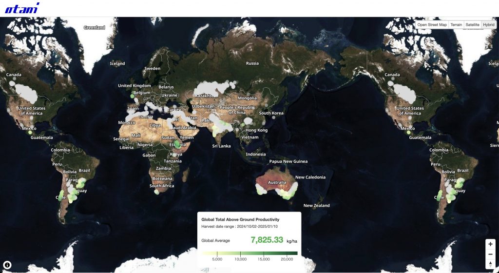
Yokohama, Japan – January 14, 2025 – Otani & Co. is pleased to announce the launch of “O2 Grain Pulse – Spring Wheat”, a global crop production index based on satellite data. Utilizing data from sources such as Copernicus satellites, this platform provides timely and consistent insights into global spring wheat productivity.

Key Features of “O2 Grain Pulse – Spring Wheat”

  1. Global and Localized Data:
  • Offers metrics for Global Total Above Ground Productivity and localized Total Above Ground Productivity (TAGP) at two resolutions:
    • 12.5 km x 12.5 km grids (approximately 30,000 globally)
    • 300 m x 300 m grids (approximately 30 million globally)
  1. Accessible Data for Analysis: 
  • Users can download TAGP data in CSV format, enabling comparisons across regions and countries. The consistent calculation methodology ensures reliable cross-border analyses.
  1. Additional Metrics for High-Resolution Grids:
  • The 300 m x 300 m grids provide further details, including:
    • Estimated total above-ground productivity within the grid
    • Field area measurements• Predicted harvest quantities
    • Estimated market prices for wheat and flour
  1. Regular Updates:
  • Data is refreshed daily for each grid, allowing users to combine datasets and generate new insights based on current information.
  1. Broad Applications:
  • The platform’s datasets can be applied to:
    • Forecast commodity prices
    • Analyze stock market trends (e.g., Nikkei 225)
    • Evaluate the performance of companies in milling, food production, and dining sectors
  1. Potential Future Enhancements:
  • Otani & Co. is considering integrating tools to generate detailed reports using imported datasets and satellite imagery, providing additional value for users.

Service Overview

  • URL: https://otani.co/o2/grain-pulse/spring-wheat/
  • Pricing: Free of charge
  • Coverage: 
    • Global, with approximately 30,000 grids at 12.5 km x 12.5 km resolution
    •  Approximately 30 million grids at 300 m x 300 m resolution
  • Target Crop: Spring Wheat (including winter wheat in the Southern Hemisphere)

Press Release

English: https://otani.co/press-release/o2-20250114-EN.pdf

Japanese : https://otani.co/press-release/o2-20250114-JA.pdf

Brisbane Cloud Cover in Dec 2023

This map visualizes cloud fraction around Brisbane throughout December 2023. White areas represent high cloud cover (1.00), while blue areas indicate thinner clouds (closer to 0.00). Refer to the legend for the exact color scale.

While some thinner cloud cover appeared intermittently, the month generally experienced significant cloudiness. Data was unavailable on the 2nd, 7th, 12th, 19th, 24th, and 31st. Only 7 days had completely clear skies: December 6th, 8th, 15th, 16th, 23rd, 28th, and 29th.


Focusing on the area closest to Brisbane City (north of the Story Bridge), we see the maximum cloud cover (1.00) occurred on December 1st, 14th, 15th, 17th, 21st, 22nd, 25th, and 30th. The lowest cloud cover (0.01) was recorded on December 11th.


The data used for this map comes from NASA Earth Observations. It was created with O2, a platform where you can load various satellite data.


You can create an account directly on O2 to access the data and visualizations.

About Publishing New API

The new API that is available inside O2 is going to be released soon!

At the time, you will retrieve the data from the two data sources, JAXA Earth API and NASA NEO. You will be notified via email and the blog article will be posted when it becomes public. The new blog post will contain the details of the API and a link to help. Plus, the two formats, geojson and csv, will be available when you request the data to the API. Using Python (pandas and geopandas), it will be easy to directly read the data from the urls.

In O2, you can use the data in two ways, Point (geojson has two properties, latitude and longitude ) and Polygon as you can click both of them on this map (the land surface temperature on January around Japan).

The data comes from JAXA Earth API, and the map was created using O2 to visualize this data.

You can create an account directly on O2 to access the data and visualizations.

Sea Surface Temperature around New Zealand (2023)

This map purposes to illustrate the sea surface temperature around New Zealand in 2023.

MonthnMin25%50%Mean75%MaxSD
Jan4811913.5817.4719.8019.1620.6622.211.89
Feb4811914.5918.2420.3219.6421.0522.181.71
Mar4811913.9117.2019.4818.9720.6721.991.95
Apr4811911.7215.3918.0717.5119.5821.092.38
May4811910.9714.8617.1516.4518.3620.052.33
Jun481199.5813.7715.9715.1816.9618.992.28
Jul481198.3512.7214.7313.9915.6817.642.25
Aug481197.8612.0513.9013.2114.8716.692.23
Sep481198.3012.3113.9513.3615.0416.742.24
Oct481198.4512.3914.1613.6315.4417.032.24
Nov4811910.0613.7015.4514.9216.4618.422.04
Dec4811910.9314.9316.8316.4518.2820.202.25
SST around New Zealand

Although its fluctuation decreases, the mean of the sea surface temperature around New Zealand seems to gradually increase as the summer arrives in the southern hemisphere. This trend can be seen in other statistics as well.

The data used comes from SST and SST Anomaly, NOAA Global Coral Bleaching Monitoring, 5km, V.3.1, Monthly, 1985-Present. This map is created with O2 where you can load the various satellite data. This sea surface temperature data will be available soon on O2.

You can create an account directly on O2 to access the data and visualizations.

Sea Surface Temperature around Japan (Jan – Apr 2023)

This map shows the sea surface temperature around Japan from January to April 2023.

MonthnMin25%50%Mean75%MaxSD
Jan219225-1.3711.9419.2317.1422.7626.766.80
Feb215832-1.8110.8818.4316.4222.1526.056.95
Mar210268-1.3211.6519.0417.1222.4126.066.47
Apr222005-1.0412.2919.2817.5923.2527.036.75
SST around Japan

The mean and standard deviation, along with other statistics, show slight changes over time. However, the map and its legend reveal a more significant shift: the area with sea surface temperatures (SST) exceeding 25 degrees Celsius has been expanding. Counting the number of points with SST above 25 degrees Celsius highlighted this difference; points observed in April were four times the number of those in March. In contrast, the number of points with SST below 10 degrees Celsius has remained stable for four months. These contrasting trends in high and low temperature points motivate depicting histograms to visualize the data distribution.

MonthAbove 25 (C) Below 10 (C)
Jan1384641011
Feb827248011
Mar578639707
Apr2563239389
The Number of Points Observing Extreme Values

The data used comes from SST and SST Anomaly, NOAA Global Coral Bleaching Monitoring, 5km, V.3.1, Monthly, 1985-Present. This map is created with O2 where you can load the various satellite data. This sea surface temperature data will be available soon on O2.

You can create an account directly on O2 to access the data and visualizations.

Sea Surface Temperature around Japan (May – Aug 2023)

This map shows the sea surface temperature around Japan from May to August 2023. The summarized data is on the table below.

MonthnMin25%50%Mean75%MaxSD
May2320690.4614.9620.4919.1324.3328.606.52
Jun2372933.7320.0623.4522.3426.8929.535.61
Jul2375788.3023.9327.2825.7129.1630.474.47
Aug2375789.8027.2328.6927.2329.0230.573.40
SST around Japan

The standard deviation gradually decreases while the mean increases as summer arrives in the northern hemisphere. This highlights one of the key points in time-series data analysis: carefully observing changes in standard deviation and exploring the reasons behind these shifts over time.

The data used comes from SST and SST Anomaly, NOAA Global Coral Bleaching Monitoring, 5km, V.3.1, Monthly, 1985-Present. This map is created with O2 where you can load the various satellite data. This sea surface temperature data will be available soon on O2.

You can create an account directly on O2 to access the data and visualizations.

Sea Surface Temperature around Japan (Sep – Dec 2023)

This map shows the sea surface temperature around Japan from September to December 2023. The table described below summarizes the data.

MonthnMin25%50%Mean75%MaxSD
Sep2375789.6025.4028.5326.7529.1830.033.61
Oct2375788.3821.2825.9724.0027.9929.745.09
Nov2369433.6317.3623.2921.1925.9929.036.21
Dec229384-0.2714.1421.2019.0124.5428.587.02
SST around Japan

An interesting point is that the standard deviation gradually increases while the mean decrease as winter arrives in the northern hemisphere.

The data used comes from SST and SST Anomaly, NOAA Global Coral Bleaching Monitoring, 5km, V.3.1, Monthly, 1985-Present. This map is created with O2 where you can load the various satellite data. This sea surface temperature data will be available soon on O2.

You can create an account directly on O2 to access the data and visualizations.

Japan Daytime Land Surface Temperature (8-day) (2022 – 2023)

The purpose of this map is to illustrate the daytime land surface temperature from January 2022 to December 2023. The data had been collected by 8 days. The range was between -33.97 and 55.93 degrees Celsius. The highest temperatures reached over 55 degrees Celsius in August 2022. This was observed around Sendai area in Tohoku region. The data comes from JAXA Earth API., and the map was created using O2 to visualize this data.

You will directly create the account here, and then directly access to O2 from your page.

Japan Nighttime Land Surface Temperature (8-day) (2022 – 2023)

This map shows the nighttime land surface temperature from January 2022 to December 2023. The data had been collected by 8 days. The range was between -8.03 and 38.09 degrees Celsius. Summer temperatures reached highs of over 35 degrees Celsius in both 2022 and 2023. Plus, you can see that temperatures dropped suddenly from November to December 2023. The data comes from JAXA Earth API., and the map was created using O2 to visualize this data.

You will directly create the account here, and then directly access to O2 from your page.

Kanto Land Price Transition (1983-2023)

This is a map to illustrate the transition of land price from 1983 to 2003 in Kanto region. It could be obviously considered that the current land price increase has been occuring in the area only around Tokyo and Kanagawa. The used data comes from 国土数値情報. The MLIT data can be downloaded from 地価公示データ, and the prefecture data is based on 都道府県地価調査.

You will directly create the account here, and then directly access to O2 from your page.