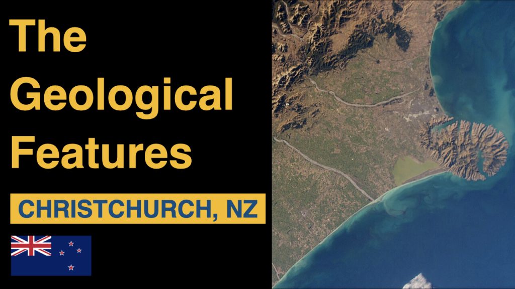
Christchurch, New Zealand’s Garden City, is not only renowned for its lush parks and vibrant urban life but also for its intriguing geological features. Located on the east coast of the South Island, Christchurch sits in a region with a rich geological history shaped by natural forces over millions of years. This article delves into the unique geological features that define Christchurch and its surrounding areas.
The Canterbury Plains
Christchurch is situated on the Canterbury Plains, a vast expanse of flat land that stretches from the Southern Alps to the Pacific Ocean. These plains were formed through a combination of tectonic activity and sediment deposition. Over millions of years, rivers flowing from the Southern Alps carried sediment down to the plains, creating the broad, fertile landscape seen today. The plains are characterized by their alluvial soils, which are ideal for agriculture, contributing significantly to the region’s farming economy.
Banks Peninsula
One of the most striking geological features near Christchurch is Banks Peninsula, a rugged, volcanic landform jutting into the Pacific Ocean. Banks Peninsula was formed by volcanic activity around 11 million years ago. It comprises two main volcanic centers, the Lyttelton and Akaroa volcanoes. Over time, erosion and sea-level changes have shaped the peninsula’s distinctive harbors and bays, such as Lyttelton Harbour and Akaroa Harbour. These natural harbors are remnants of the original volcanic craters and offer a glimpse into the region’s fiery past.
Port Hills
The Port Hills, which separate Christchurch from Lyttelton Harbour, are the remnants of the ancient Lyttelton volcano. These hills provide stunning views of the city, the plains, and the ocean. Composed primarily of basaltic rock, the Port Hills are a popular destination for hiking, biking, and outdoor activities. They also serve as a natural barrier, influencing the local climate by providing shelter from coastal winds.
The Canterbury Earthquakes in Christchurch
Christchurch’s recent geological history has been significantly influenced by seismic activity. The region is located near the boundary of the Pacific and Australian tectonic plates, making it prone to earthquakes. The 2010 and 2011 Canterbury earthquakes had profound impacts on Christchurch. The 2011 earthquake, in particular, caused extensive damage due to its proximity to the city and shallow depth.
These earthquakes revealed much about the underlying geology of the region. Liquefaction, where saturated soils temporarily lose their strength, was a major issue in many parts of Christchurch. The earthquakes also led to the discovery and re-evaluation of fault lines and seismic hazards in the area. The rebuilding efforts post-earthquake have focused on enhancing the city’s resilience to future seismic events, incorporating advanced engineering and construction techniques.
The Avon River
The Avon River is a key geological and cultural feature of Christchurch. Flowing through the heart of the city, the river originates from springs in the west and meanders through parks and the central business district before emptying into the Pacific Ocean. The river’s presence has shaped the city’s development, providing a natural focal point for recreation and relaxation. The riverbanks are characterized by alluvial soils, contributing to the lush greenery of the surrounding areas.
The Southern Alps and Glacial Influence
While not within the city itself, the proximity of the Southern Alps has a significant geological influence on Christchurch. The Alps were formed by the collision and uplift of the Pacific and Australian tectonic plates. Glacial activity during the last Ice Age carved out valleys and deposited material across the plains. This glacial influence is evident in the gravels and sediments found throughout the Canterbury Plains.
The Gravel Pits
The Gravel Pits, located in the western suburbs of Christchurch, provide a window into the geological history of the area. These pits expose layers of gravel and sediment deposited by ancient rivers flowing from the Southern Alps. The gravels are often used in construction and provide insights into past climatic conditions and river dynamics.
Conclusion
The geological features of Christchurch, from the flat expanses of the Canterbury Plains to the volcanic remnants of Banks Peninsula and the Port Hills, create a diverse and fascinating landscape. The region’s seismic activity and the influence of the Southern Alps add further layers of complexity to its geological story. Understanding these features not only enriches our appreciation of Christchurch’s natural beauty but also underscores the dynamic and ever-changing nature of the Earth. Whether you’re exploring the rugged hills, strolling along the riverbanks, or visiting the harbors, the geological wonders of Christchurch offer a unique and enriching experience.